Historical Maps of India and South Asia
A list of online resources
May 2016
Making of maps or visual references of our world has been an important part of human history to make sense of where we live, travel or simply learn about. Maps of India and south Asian region have also existed since centuries. In this list, we bring you a cross section of historical maps that you may find online. Needless to say that the veracity or authenticity of information given in these maps exists with their respective designers/artists.
Map of India in the Age of the Mahabharata (World Digital Library)
https://www.wdl.org/en/item/144/
World History (3000 BC - 2013 AD) A video of history's timeline.
https://www.youtube.com/watch?v=ewd4l2rD2_U
 India and South Asia: 1000BC - 200BC (TimeMaps) India and South Asia: 1000BC - 200BC (TimeMaps)
Interactive map that shows basic details.
http://www.timemaps.com/history/south-asia-500bc
Map of India, 600 BCE
http://www.ancient.eu/image/321/
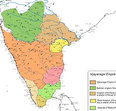
Map of Vijayanagar Empire, circa 1350 CE
https://jambudveep.wordpress.com/category/historical-map-of-india-project/
The Mughal Empire in Northern India 1500 - 1900 (A video)
https://youtube.com/watch?v=AWaOd-QYP8w
Historical maps of Indian towns and cities (1893, 1909, 1924)
http://www.indiawaterportal.org/articles/historical-maps-indian-towns-and-cities-
1893-1909-1924
India 1804 (interactive map using satellite map) David Rumsey Collection
Map shows the British colonies in India at the beginning of the 19th century.
David Rumsey's website allows users to plot many historical maps onto today's satellite imagery through Georeferencer (http://www.davidrumsey.com/view/georeferencer)
http://rumsey.geogarage.com/maps/g2310061.html
Historical Map of India 1700-1792
http://www.emersonkent.com/map_archive/india_1700.htm
 Historical Map: The Beginnings of the British Dominion Historical Map: The Beginnings of the British Dominion
http://www.emersonkent.com/map_archive/india_1783.htm
Map of Northern India: The Mutiny 1857-1859 (Principal centres of mutiny)
http://www.emersonkent.com/map_archive/india_1857.htm
The changing map of India from 1 AD to the 20th century
http://scroll.in/article/722369/the-changing-map-of-india-from-1-
ad-to-the-20th-century
Historical Maps of India
http://homepages.rootsweb.ancestry.com/~poyntz/India/maps.html
Historical and Political Maps of India
by Joaquín de Salas Vara de Rey (Euratlas)
http://www.euratlas.net/history/hisatlas/india/
Original home of the Aryan tribes and their migrations 1500 BC
http://www.globalsecurity.org/military/world/india/images/map-1500bc-aryans.jpg
Tughlaq Rule
https://hyderabadhistory.files.wordpress.com/2015/03/tughlaq-map-e1426886948793.jpg
Delhi Khanate
http://2.bp.blogspot.com/-liWvND3rEMg/USwUKkckU0I/AAAAAAAABjQ/2tyzzopj8nI/
s1600/MongolIndia.png
Tughlaq dynasty
http://www.columbia.edu/itc/mealac/pritchett/00maplinks/medieval/
roolvinkset/tughlaqmax.jpg
Khalji dynasty
http://www.columbia.edu/itc/mealac/pritchett/00maplinks/medieval/
roolvinkset/khaljimax.jpg
Empire of Mohammad bin Tughlaq
http://www.columbia.edu/itc/mealac/pritchett/00maplinks/medieval/daviesset/1335max.jpg
India in 1398
http://www.columbia.edu/itc/mealac/pritchett/00maplinks/medieval/daviesset/1398max.jpg
COLONIAL MAPS from c.1750 to c.1900 (Francis Pritchett)
http://www.columbia.edu/itc/mealac/pritchett/00maplinks/colonial/colonial_index.html
The battle of PLASSEY, 1757 map
http://www.columbia.edu/itc/mealac/pritchett/00maplinks/colonial/plassey1757/
plassey1757.html
"India" by Edward Weller, for the Weekly Dispatch Magazine, c.1859
http://www.columbia.edu/itc/mealac/pritchett/00maplinks/colonial/wellermaps/
india1859/india1859.html
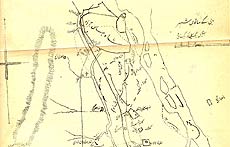 HISTORICAL SHAHJAHANABAD (1919) Urdu map HISTORICAL SHAHJAHANABAD (1919) Urdu map
from Bashir ud-Din Ahmad Dihlavi, Vaqi'at ul-hukumat-e Dehli (Agra: Shams Machine Press, 1919)
http://www.columbia.edu/itc/mealac/pritchett/00maplinks/colonial/
bashir1919/bashir1919.html
Seven Cities of Delhi (Urdu)
http://www.columbia.edu/itc/mealac/pritchett/00maplinks/colonial/bashir1919/sevencities.jpg
Qila-e Mu'alla: Red Fort of Delhi before 1857
http://www.columbia.edu/itc/mealac/pritchett/00maplinks/colonial/
bashir1919/redfortpre1857.jpg
Mapping the cosmos: When religious symbolism meets historical maps (report on exhibition)
http://hindustantimes.com/art-and-culture/mapping-the-cosmos-when-religious-
symbolism-meets-historical-maps/story-aFhmJDufcpxIX0VJetBetK.html
Maps and Map-making in India (University of Michigan)
http://www.lib.umich.edu/online-exhibits/exhibits/show/india-maps
Al-Idrisi to Ptolemy: Early Maps of India
http://www.lib.umich.edu/online-exhibits/exhibits/show/india-maps/early-maps
Military movements Bangladesh 1971 Liberation War
https://origins.osu.edu/sites/origins.osu.edu/files/Military%20movements%20of%20
Bangladesh_1971_Liberation.jpg
British India Map
https://origins.osu.edu/sites/origins.osu.edu/files/british-india-map.jpg
Durand Line Border between Afghanistan and Pakistan
https://origins.osu.edu/sites/origins.osu.edu/files/Durand_Line_Border_Between_
Afghanistan_And_Pakistan.jpg
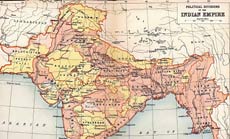
British Indian Empire 1909
https://origins.osu.edu/sites/origins.osu.edu/files/British_Indian_Empire_1909_Imperial
_Gazetteer_of_India.jpg
Railway Maps and Geographic Resources (Indian Railways Fan Club)
http://irfca.org/docs/maps.html
Perry-Castañeda Library Map Collection (India)
Some of the topographical maps featured on this page were produced by
the CIA of United States. Some are from other sources.
http://www.lib.utexas.edu/maps/india.html
Atlases and maps at Digital South Asia Library (University of Chicago)
http://dsal.uchicago.edu/maps/
50 centuries in 10 minutes (a video)
https://www.youtube.com/watch?v=dp0tqdu7fH4
Animated map shows how religion spread around the world (a video)
https://www.youtube.com/watch?v=AvFl6UBZLv4
Charting pre-historic human migration
Animated map shows how humans migrated across the globe (a video)
https://www.youtube.com/watch?v=CJdT6QcSbQ0
Spread of the world's first writing systems
Animated map shows how the world's first written languages spread
https://www.youtube.com/watch?v=Tbp9AGGdJV8
Cosmology to Cartography A Cultural Journey of Indian Maps (Exhibition)
http://www.nationalmuseumindia.gov.in/pdfs/Concept-Note.pdf
This list is in progress. Please let us know if you know of some good Oral history archive on the Internet which concerns us and we may have missed. Please report if you find any dead links. |